
News & Media
What happened in Nepal: anatomy of a flood that (perhaps) could have been predicted
Nepal emergency: where things stand
According to the latest update of the Nepalese police, the confirmed victims in Nepal are, as of 6:00 p.m. Italian time on 27 August, about 359, and the toll keeps rising as the searches progress. The missing people are 826 and the injured under treatment dozens.
On the Tibetan side the Chinese authorities reported three victims and 558 missing. Overall, between the two countries, the people not yet traced exceed 1,300.
Among the missing in Nepal are 579 travellers (113 Nepalese and 466 foreigners, of about thirty different nationalities), 161 residents of the Rasuwa district, 85 between military and officers engaged in the rescue operations — 44 of the Army, 28 of the Police, 13 of the Armed Police — and one person from Nuwakot.
A considerable part of the travellers was heading to Mount Kailash through the Kerung crossing. A group of 77 pilgrims was at the immigration office at the border when the water arrived.
It must be specified that “missing” indicates a person not yet traced. In an area where communications are interrupted and the roads no longer exist, many are simply unreachable. It is not a list of victims, and the Nepalese authorities are verifying it together with travel agencies, guides and local administrations.
What happened
On Wednesday 26 August, around 8:40 in the morning, a large portion of glacier broke off in Tibetan territory above the course of the Lhende river. The mass of ice and debris dammed the river forming a natural dam. When the barrier gave way, all the accumulated water poured downstream in a single wave.
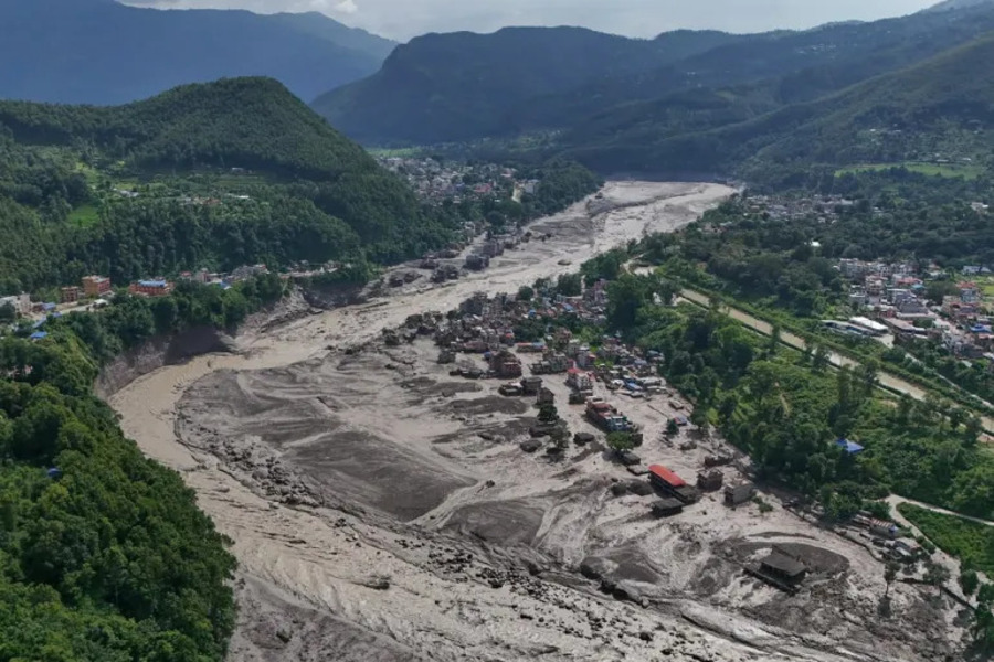
The wave descended along the Lhende Khola, flowed into the Bhote Koshi and then into the Trishuli. The level of the Trishuli rose by about nine metres in thirty minutes.
At 9 the flood reached Timure, at the Rasuwagadhi crossing, and Syabrubesi, the gateway to the Langtang valley. It then crossed the districts of Nuwakot, Dhading and Gorkha, continuing south until flowing into the system that drains into India.
It was not an earthquake
The first reconstructions, taken up by almost the entire international press, attributed the trigger to an earthquake of magnitude 4.4 recorded at 8:37 on the Tibetan side.
The United States Geological Survey corrected this reading. Analysing the seismic signal, the American agency established that no earthquake occurred: the long-period seismic waves recorded were produced by the glacial collapse and by the debris flow that followed. The magnitude was revised from 4.4 to 5.2, but it is the instrumental recording of the collapse itself, not a tectonic event.
The difference is not a detail. It means that at the origin there was no shock that destabilized the glacier, but the yielding of the glacier itself. Daniel Shugar, geomorphologist at the University of Calgary, indicated as the probable mechanism the infiltration of meltwater from snow and ice, which would have lubricated the base of the glacier until causing its detachment.
The Department of Hydrology and Meteorology of Nepal had already ruled out that the flood could be traced back to local precipitation: in the preceding hours it was not raining. ICIMOD also identified through satellite images the emptying of a supraglacial lake on the Purepu glacier, across the border.
Where the water reached
The bodies were recovered in eight different districts, and only two in Rasuwa. The others in Chitwan, Dhading, Nawalparasi East, Gorkha, Nuwakot, Tanahun and Nawalparasi West.
The distribution gives the measure of the distance travelled by the flood along the Lhende–Bhote Koshi–Trishuli system, and explains why the search operations involve an area much wider than the affected district.
Damage and access
In Timure the market, the customs area and the public offices were swept away, together with hundreds of vehicles waiting for customs clearance. The settlement of Khalte was completely destroyed. The satellite images show Syabrubesi buried by mud; in some localities on the Tibetan side the deposits reach one and a half metres in thickness.
About 40 kilometres of road between Betrawati and the border and at least 19 bridges were lost, including the one rebuilt after the flood of July 2025. The government indicated Uttargaya among the most affected local administrations.
The hydroelectric plants of the area are out of use and the electricity supply is interrupted. The villages upstream are not reachable by land.
The emergency supplies pre-positioned in the area were destroyed by the flood. It is an element that conditions the whole response: the warehouse from which the first distributions would have been supplied no longer exists, and every good must be brought from outside.
The rescue operations
Thirteen helicopters, of the Nepalese Army and private ones, are engaged in the searches. On Thursday morning alone the Army rescued more than one hundred people, including some foreign citizens transported to Kathmandu.
Forty-two doctors of the security forces have been assigned to five hospitals, where treatment for the injured is free of charge. A national toll-free number (1234) is active for reports.
The bad weather continues to interrupt flights, and the destruction of the Timure helipad prevented in the first hours any landing in the most affected area.
The response of the authorities
The Council of Ministers declared the affected local administrations disaster crisis zones for the next three months. The measure activates the rescue protocols, the compensations to the families of the victims and the obligation to transfer to safe places those who lost their home.
25 million rupees in total have been allocated for the emergency funds of Rasuwa, Nuwakot and Dhading. The competent ministries have received the mandate to restore roads, the electricity grid, drinking water and telecommunications. The Ministry of Foreign Affairs is coordinating with China and India the requests for assistance.
The risk is not over
The monsoon is not over. Every new rainfall on the destabilized slopes entails the risk of landslides, with the possibility that the access routes just reopened may close again.
The authorities are also monitoring the situation upstream, where the debris mobilized by the collapse may have formed new barriers along the watercourse.
It is not the first time
On 8 July 2025 the same valley had been hit by a similar event, caused by the emptying of a supraglacial lake in Tibetan territory: nine dead, the Friendship Bridge between Nepal and China destroyed, cross-border trade interrupted for six months. The dry port of Timure, damaged at the time, had not yet returned fully operational.
Until a few years ago, in the Hindu Kush Himalaya a flood of glacial origin was recorded every five or ten years. Only between May and June 2025 ICIMOD counted three of them in two months, between Nepal, Afghanistan and Pakistan. In the forecasts for the 2026 monsoon the same centre had indicated the increase of these events among the main risks for the region, together with temperatures higher by 0.5-2 °C compared to the average of the 2010-2024 period.
The lake that emptied above Rasuwa, according to the satellite analysis of ICIMOD, at the end of 2024 was still a small pool on the glacier.
ASIA in Rasuwa
We have been working in this district since 2015, the year of the earthquake that devastated the entire area. We know these communities and the difficulties they live with. Our team is on the ground for the assessment of the needs and is organizing a first humanitarian intervention together with the local partners.
The immediate priorities are shelter for the displaced families, drinking water and sanitation where the pipelines failed, food supplies until the markets reopen, and health care in the villages that at the moment no vehicle manages to reach.
Pubblicato il
26/08/2026